No higher resolution available.
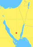
Map os Sinai Penisula, showing location of Jabal Musa (aka Mt Sinai) Lat 28.53417 N Lon 33.97361 E This image is from en.wikipedia.org It's orginal work by Robert Dodier (User: Wile E. Heresiarch) Licene CC v. 1.0 Drozdp 17:49, 18 September 2005 (UTC) This file is licensed under the Creative Commons Attribution-Share Alike 3.0 Unported license.
You are free:
       to share – to copy, distribute and transmit the work
              to remix – to adapt the work
Under the following conditions:
       attribution – You must attribute the work in the manner specified by the author or licensor (but not in any way that suggests that they endorse you or your use of the work).
              share alike – If you alter, transform, or build upon this work, you may distribute the resulting work only under the same or similar license to this one.
This file is licensed under the Creative Commons Attribution-Share Alike 3.0 Unported license.
http://commons.wikimedia.org/wiki/File:Jabal-musa-location.png
Click on a date/time to view the file as it appeared at that time.
| Date/Time | Thumbnail | Dimensions | User | Comment | |
|---|---|---|---|---|---|
| current | 00:21, 5 February 2013 |  |
115 × 163 (7 KB) | Luiz Alexandre Silva (Talk | contribs) | Map os Sinai Penisula, showing location of Jabal Musa (aka Mt Sinai) Lat 28.53417 N Lon 33.97361 E This image is from en.wikipedia.org It's orginal work by Robert Dodier (User: Wile E. Heresiarch) Licene CC v. 1.0 Drozdp 17:49, 18 September 2005 (UTC) Thi |
There are no pages that link to this file.