| Arches National Park | |
|---|---|
| IUCN Category II (National Park) | |
| | |
| Location | Utah, USA |
| Nearest city | Moab, UT |
| Area[1] | 76,679 acres (310.3 km²) {76,546 acres (309.8 km²) federal} |
| Established | April 12, 1929 ( Monument ) November 12, 1971 ( Park ) |
| Visitors[2] | 860,181 (in 2007) |
| Governing body | U.S. National Park Service |
| Entrance fee | $5/person or $10/vehicle for 7 days |
| Website | NPS - Arches |
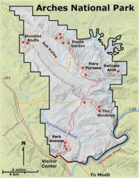
The entrance to Arches is located 5 miles north of Moab, in Eastern Utah along Highway 191. The park was established in 1929 and covers 82,953 acres.
Arch Collapses[edit]
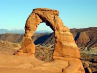
Gravity and erosion have caused a couple of arch collapses. Landscape Arch fell in 1991. The Wall Arch collapsed in August 2008.[3] [4]
References[edit]
- ↑ NPS Listing of Acreage 9/30/2008
- ↑ NPS Reports -> Ranking Report -> 2007
- ↑ Wall Arch Collapses, National Park Service, August 8, 2008
- ↑ Famous Stone Arch Collapses in Utah Park, Associated Press, Fox News Channel, August 10, 2008
Sources[edit]
- Official Website
- NPS Visitor Guide
- Student Guide
- Virtual Tour of Arches National Park
- The New American Desk Encyclopedia, Penguin Group, 1989


